
The Godavari River is the largest river in Peninsular India and holds immense geographical and cultural importance. Because of its great age, vast size, and long course, it is popularly known as the Dakshin Ganga (Southern Ganges) and Vridha Ganga (Old Ganga). The river system is also referred to as the Gautami river system, reflecting its historical and mythological significance.
Flowing across vast plateaus and fertile plains, the Godavari supports millions of people through agriculture, fisheries, transportation, and drinking water supply before finally emptying into the Bay of Bengal.
Table of Contents
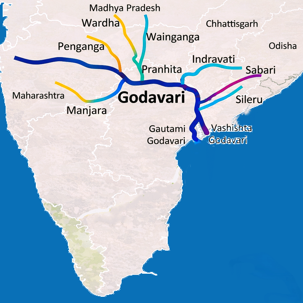
Godavari River System Map
Origin of Godavari River
- The Godavari River originates in the Western Ghats near Trimbakeshwar, in the Nashik district of Maharashtra.
- Its source lies close to Brahmagiri Hill, at an elevation of about 1,067 meters above sea level.
- Trimbakeshwar is not only the birthplace of the river but also an important pilgrimage center, home to one of the twelve Jyotirlingas of Lord Shiva.
Course of Godavari River
- From its origin in the Western Ghats, the Godavari flows eastward across the Deccan Plateau, passing through three states: Maharashtra, Telangana, and Andhra Pradesh before reaching the Bay of Bengal.
- Stretching for about 1,465 kilometers (910 miles), the Godavari is the second longest river in India, after the Ganga.
- Its long course drains the third largest river basin in the country, covering nearly 10% of India’s total geographical area, which makes it a vital lifeline for central and southern India.
- The river’s journey from the mountainous region to the eastern coast shapes vast plains and fertile valleys, making it one of the most significant river systems in India.
| State | Key Course / Major Districts | Tributaries Joined |
|---|---|---|
| Maharashtra | Originates near Trimbakeshwar (Brahmagiri Hill, Western Ghats, Nashik); flows through Nashik, Ahmednagar, Aurangabad, Parbhani, Nanded, Paithan | Pravara, Mula, Penganga, Wardha, Wainganga, Purna, Pench, Kanhan |
| Telangana | Enters near Telangana in Nizamabad district; flows through Mancherial, Ramagundam, Jayashankar Bhupalpally, Kaleshwaram | Pranhita (combined Penganga and Wardha rivers), Indravati, Maner, Manjira and Kadam. |
| Andhra Pradesh | Enters near Polavaram; flows through Alluri Sitharama Raju district, Rajahmundry; forms delta | Sabari, Godavari distributaries: Gautami, Vashishta |
Course of Godavari River in Maharashtra
- The Godavari River originates near Trimbakeshwar in the Nashik district of Maharashtra, close to Brahmagiri Hill in the Western Ghats.
- After its origin, the river flows eastward through Nashik city (site of Kumbh Mela), where it becomes an important center for religious, cultural, and economic activities.
- It then continues its course through the Ahmednagar district, flowing across the Deccan Plateau and supporting agriculture in the surrounding regions.
- The Godavari further flows through parts of Aurangabad district, where several tributaries join it, increasing its volume.
- Near Paithan, the river is joined by the Pravara River, one of its major tributaries in Maharashtra.
- The river is impounded at Paithan in the Aurangabad district to create the Jayakwadi Dam (NathSagar Reservoir), which is one of India’s largest earthen dams designed to combat drought in the Marathwada region.
- The river continues eastward through Parbhani and Nanded districts, forming fertile river plains that support farming and settlements.
- The Pranhita River (combined flow of Penganga, Wardha, and Wainganga) joins the Godavari near Sironcha, near the Maharashtra-Telangana border.
- Finally, the Godavari leaves Maharashtra near the town of Sironcha in the Gadchiroli district, entering the state of Telangana and continuing its eastward journey toward the Bay of Bengal.
- The Godavari river forms a significant part of the state’s agriculture, with about 59.57% of its basin area used for agriculture. It drains the Marathwada and Vidarbha regions and forms part of the state boundary between Maharashtra and Telangana.
Course of Godavari River in Telangana
- The Godavari River enters Telangana in Nizamabad district at Kandakurthy village (Renjal mandal). At this point, it forms a “Triveni Sangamam” by joining with the Manjira and Haridra rivers.
- It flows near Basara (Nirmal district) and enters the Sriram Sagar Dam reservoir. Basara is an important religious center known for the Gnana Saraswati Temple.
- The river flows eastward through Nirmal and Mancherial districts, forming a natural boundary in some stretches and supporting dense forests and agricultural land.
- Near Mancherial, the Pranahita River (combined Penganga and Wardha rivers), the largest tributary of the Godavari, joins it, greatly increasing the river’s volume.
- The Godavari then flows past Ramagundam, an important industrial and power-generation center in Telangana.
- Further east, the river passes through the Jayashankar Bhupalpally district, flowing through hilly and forested regions of northern Telangana.
- Near Kaleshwaram, the Manair River joins the Godavari, and the river becomes a key part of the Kaleshwaram Lift Irrigation Project.
- Flows southeast through Bhadradri Kothagudem district, passing through the Papi Hills gorge.
- Flows southeast through Bhadradri Kothagudem district via the Papi Hills gorge.
- Passes the pilgrimage town of Bhadrachalam (known for the Sri Sita Ramachandra Swamy Temple) in Bhadradri Kothagudem district, before exiting the state and entering Andhra Pradesh near the Polavaram area.
Course of Godavari River in Andhra Pradesh
- After leaving Telangana, the river enters the Alluri Sitharama Raju (ASR) and Eluru districts of Andhra Pradesh.
- It cuts through the Papi Hills (Eastern Ghats) to form the narrow and scenic Bison Gorge.
- Near Kunavaram in the Alluri Sitharama Raju district, the Godavari receives its last major left-bank tributary, the Sabari River. This confluence significantly increases the river’s volume before it reaches the plains.
- At Polavaram, the river emerges from the last range of the Eastern Ghats into the coastal plains. This is the site of the Polavaram Multipurpose Project, a national project designed for massive irrigation, hydropower, and drinking water supply.
- After Polavaram, the Godavari enters the coastal plains of Andhra Pradesh, where the river widens and slows down.
- Below the Dhavaleswaram Barrage (Sir Arthur Cotton Barrage) near Rajahmundry, the river splits into two main distributaries: the Gautami Godavari and the Vashishta Godavari, marking the beginning of its vast delta.
- In its lower reaches, the river acts as a natural boundary separating the East Godavari and West Godavari districts.
- Finally, the distributaries of the Godavari empty into the Bay of Bengal, completing the river’s long journey from the Western Ghats to the eastern coast of India.
Godavari Delta UPSC
- The Godavari Delta begins to form near Rajahmundry, approximately 80 km from the coast, where the river spreads out and develops a wide network of distributaries, greatly increasing the region’s fertility and agricultural potential.
- Below Rajahmundry, the Godavari divides into two main streams: the Gautami Godavari flowing to the east and the Vashishta Godavari flowing to the west. These two streams together shape a vast deltaic region before entering the Bay of Bengal.
- The Godavari Delta is a lobate delta, characterized by a rounded bulge at the coast and numerous branching distributaries. It is formed by large deposits of river-borne alluvium laid down at the river’s mouth.
- Continuous silting at the river mouth is an ongoing process, which gradually extends the delta seaward over time.
- Before meeting the Bay of Bengal, the Godavari further divides into seven distributary mouths, collectively known as the Sapta Godavari. Before this division, the river is referred to as the Akhanda Godavari (undivided Godavari).
- The seven mouths of the Godavari are named:
- Tulyabhaga (Kasyapa),
- Atreya (Atri),
- Gautami (Gautama),
- Vṛddhagautami (replacing Jamadagni),
- Bhardvaja (Bharadvaja),
- Kausika (Vishvamitra), and
- Vashishta (Vasishtha).
- The delta contains the Coringa Wildlife Sanctuary (Coringa Mangrove Forest), the third-largest mangrove system in India, known for its biodiversity.
- The delta region is one of the most fertile areas in India, supporting intensive agriculture, especially rice cultivation, and sustaining dense rural populations along the eastern coast.
- Godavari Delta is known as the “Rice Granary of South India” or “Rice Bowl of Andhra Pradesh”.
Tributaries of Godavari River
The Godavari River is fed by a large network of tributaries that drain much of central and southern India. These tributaries are usually classified into left-bank and right-bank tributaries based on the direction of flow.
Left Bank Tributaries of Godavari River
The left-bank tributaries of the Godavari River are more numerous and larger than the right-bank tributaries and together drain nearly 59.7% of the total basin area.
| Left Bank Tributary | Origin | Confluence | Key Details |
|---|---|---|---|
| Dharna (or Darna) | Kulang Hill (North of Kalsubai Range) of the Nashik district | Joins the Godavari in Nasik district of Maharashtra | Total length 80+ km; Minor left-bank tributary contributing to the upper basin; Darna Dam (or Dharna Dam) is located on the river, creating Lake Beale. |
| Penganga | Ajantha ranges in Aurangabad district in Maharashtra | Joins the Wardha to form the Pranahita | Total length 676 km; Forms part of Maharashtra–Telangana boundary; Major tributaries include the Kas, Arunavati, Kayadhu, and Pus rivers. |
| Wainganga | Mahadeo Hills, near Mundara/Partabpur in the Seoni district of Madhya Pradesh | Joins the Wardha to form the Pranahita at Chaprala in Maharashtra’s Gadchiroli district | Total length ~580 km; Drains central India; major contributor to Pranahita; Main tributaries joining the Wainganga include the Kanhan, Pench, Bawanthadi, Andhari, and Chulband rivers. |
| Wardha (or Varada) | Satpura Range near Multai in Betul district, Madhya Pradesh. | Joins the Wainganga to form the Pranahita | Total length ~528 km; Drains Vidarbha region; combines with Wainganga and Penganga. |
| Pranahita | Formed by Penganga, Wardha, and Wainganga | Joins the Godavari near Kaleshwaram (Telangana) | Total length ~113 km; Largest tributary of the Godavari River; drains ~34% of the Godavari basin; Pranahitha River flows along the eastern boundary of the Pranahita Wildlife Sanctuary. |
| Pench | Satpura Range, Chhindwara district of Madhya Pradesh | Joins the Kanhan River | Total length ~214 km; Flows through the heart of Pench National Park and dividing it into East and West sections. |
| Kanhan | Satpura Range of Chhindwara District, Madhya Pradesh | Joins the Wainganga River at Ambora (Maharashtra’s Nagpur district) | Total length ~275 km; Tributary of Wainganga; Pench River is major tributary. |
| Sabari | Sinkaram hill ranges of the Eastern Ghats in the Koraput district of Odisha | Joins the Godavari near Kunavaram in Andhra Pradesh. | Total length ~418 km; Known as the Kolab River in its upper reaches; it flows through Odisha, Chhattisgarh, and Andhra Pradesh; forms a common boundary between Odisha and Chhattisgarh; Sileru River (or Machkund) is the main tributary of the Sabari River. |
| Indravati | Mardiguda (Kalahandi, Odisha) in the Dandakaranya Range | Joins the Godavari near Bhadrakali in the Bijapur district of Chhattisgarh, near the tri-state junction of Maharashtra, Chhattisgarh, and Telangana. | Total length ~535; Called the “lifeline of Bastar,”; The river forms the spectacular Chitrakoot Falls (Niagara of Chhattisgarh); The river defines the northern border of the Indravati National Park and separating it from Maharashtra. |
Right Bank Tributaries of Godavari River
The right-bank tributaries of the Godavari River are comparatively fewer and smaller and contribute about 16.14% of the total basin area. These rivers mainly originate in the Western Ghats and Deccan Plateau and support irrigation and water supply in parts of Maharashtra and Telangana.
| Right Bank Tributary | Origin | Confluence | Key Details |
|---|---|---|---|
| Pravara | Eastern slopes of the Sahyadris (Western Ghats) between Kulang and Ratangad mountains in Ahmednagar District, Maharashtra | Joins the Godavari at Pravara Sangam near Kaygaon Toka. | Total length ~208 km; The Bhandardara dam and the scenic Randha Falls are located on the river. |
| Mula | Hills of Akola (Western Ghats) in the Ahmednagar district, Maharashtra | Merges with the Pravara River, and their combined waters flow into the Godavari near Nevasa (Pravara Sangam) in the Ahmednagar district. | Total length ~72 km; Originates in Western Ghats; feeding into the upper reaches of the Godavari Basin. |
| Manjira (Manjra) | Balaghat Range near Ahmednagar district, Maharashtra | Near Basara in Telangana, the Manjira joins the Godavari and Haridra rivers, forming a significant confluence known as the Triveni Sangam. | Total length ~724 km; Flowing through Maharashtra, Karnataka and Telangana; Key projects including the Nizam Sagar Dam and Singur Dam. |
| Peddavagu | Telangana Plateau | Joins the Godavari in Telangana | Small tributary feeding Telangana region. |
| Manair (or Maneru) | Telangana Plateau; Sircilla hills of Rajanna Sircilla district Telangana. | Joins the Godavari near Narmala village in Mahadevapur taluk, Jayashankar Bhupalpally district, Telangana. | Total length ~225 km; Fed by the Salivagu River, as well as smaller streams like Maruvancha Vagu and Bogula Vagu; Supplies water to the NTPC power plant at Ramagundam. |
Godavari River Basin and Drainage Area
The Godavari River Basin is the third largest river basin in India, covering an area of 312,812 sq km, after the Ganga and Brahmaputra, covering nearly 10% of the country’s total geographical area.
Spanning eight states—Maharashtra, Telangana, Andhra Pradesh, Chhattisgarh, Madhya Pradesh, Odisha, Karnataka and UT of Puducherry—the basin drains a vast area of central and southern India.
The Godavari basin covers about 50% of the total land area of Maharashtra.
The basin is bounded by prominent mountain ranges:
- North: Satmala Hills and Mahadeo Hills
- Northwest: Ajanta Range
- West: North Sahyadri range of the Western Ghats
- East and Southeast: Eastern Ghats
- South: Balaghat Range
The basin is roughly divided into three regions based on topography: the upper basin, which lies in the Western Ghats and the Deccan Plateau; the middle basin, covering central Maharashtra and Telangana; and the lower basin, including the fertile plains and delta in Andhra Pradesh.
| Basin Section | States Covered | Key Tributaries | Area Covered (sq km) | Percentage of Total Basin | Key Features |
|---|---|---|---|---|---|
| Upper Basin (Source to Manjira confluence) | Maharashtra, Madhya Pradesh, Chhattisgarh | Pravara, Purna, Penganga, Wardha, Wainganga, Pench, Kanhan | 157,500 | ~50% | Originates near Trimbakeshwar; flows through Western Ghats and Deccan Plateau; supports upper tributary network and upper basin agriculture. |
| Middle Basin (Manjira to Pranahita confluence) | Maharashtra, Telangana, Chhattisgarh | Manjira (Manjra), Manair (Maner), Pranahita | 94,200 | ~30% | Flows across Telangana plateau; Pranahita forms the largest left-bank tributary system; Kaleshwaram Lift Irrigation Project located here; industrial and irrigation hubs. |
| Lower Basin (Pranahita confluence to Bay of Bengal) | Telangana, Andhra Pradesh, Odisha, Puducherry | Sabari, Godavari distributaries (Gautami, Vashishta, Vashista, etc.) | 61,112 | ~20% | Fertile delta near Rajahmundry; forms lobate delta with multiple distrib |
States-wise Godavari River Basin Area
| State | Drainage Area (sq. km) | Percentage Share (%) |
|---|---|---|
| Maharashtra | 152,199 | 48.65% |
| Andhra Pradesh & Telangana | 73,201 | 23.40% |
| Madhya Pradesh | 31,821 | 10.18% |
| Chhattisgarh | 33,434 | 10.69% |
| Odisha | 17,752 | 5.67% |
| Karnataka | 4,406 | 1.41% |
| Total | 312,813 | 100% |
Dams on Godavari River
The Godavari River is home to several major dams, barrages, and irrigation projects that support drinking water supply, agriculture, flood control, and hydroelectric power generation across Maharashtra, Telangana, and Andhra Pradesh. Some key projects include:
Major Dams and Barrages on the Main River
| Dam / Barrage | State | Key Features / Purpose |
|---|---|---|
| Gangapur Dam | Maharashtra | One of the earliest earthen dams near Nashik |
| Jayakwadi Dam | Maharashtra | Major irrigation project; forms Nath Sagar reservoir |
| Babli Barrage | Maharashtra | Located near Nanded; inter-state significance |
| Sriram Sagar Project (Pochampad) | Telangana | Major irrigation and hydropower project |
| Sripada Yellampalli Project | Telangana | Irrigation and drinking water supply |
| Dummugudem Barrage | Telangana | Lift irrigation project |
| Polavaram Project | Andhra Pradesh | National multipurpose project (irrigation, hydropower, flood control) |
| Dowleswaram Barrage | Andhra Pradesh | Historic barrage near delta; supports extensive irrigation |
Key Tributary Dams in the Godavari Basin
| Dam | River (Tributary) | State | Purpose |
|---|---|---|---|
| Yeldari Dam | Purna | Maharashtra | Irrigation |
| Siddheshwar Dam | Purna | Maharashtra | Irrigation |
| Manar Dam | Manar | Maharashtra | Irrigation |
| Upper Wardha Dam | Wardha | Maharashtra | Irrigation |
Cities on the Banks of Godavari River
The Godavari River flows through several states and nurtures numerous urban centers along its course. These cities benefit from the river for agriculture, industry, transportation, and cultural significance.
| City | State | Key Features / Importance |
|---|---|---|
| Trimbakeshwar | Maharashtra | Source of Godavari River; major pilgrimage site; Jyotirlinga temple |
| Nashik | Maharashtra | Major religious center; Kumbh Mela site; industrial and agricultural hub |
| Kopargaon | Maharashtra | Important regional town in upper basin; supports agriculture |
| Aurangabad | Maharashtra | Industrial and historical city; part of upper basin; near tributaries |
| Paithan | Maharashtra | Site of Jayakwadi Dam; irrigation and flood control; historical importance |
| Gangakhed | Maharashtra | Known as “Dakshin Kashi”; religious importance |
| Nanded | Maharashtra | Major religious center; Hazur Sahib Gurudwara; Vishnupuri Barrage nearby |
| Nagpur | Maharashtra | Major industrial city; located in tributary basin (Wardha–Wainganga system) |
| Basar | Telangana | Famous Gnana Saraswati Temple |
| Nizamabad | Telangana | Agricultural and industrial center; benefits from Sriram Sagar Project |
| Ramagundam | Telangana | Major industrial hub; thermal power plants nearby |
| Mancherial | Telangana | Industrial and mining region in middle basin |
| Kaleshwaram | Telangana | Site of Kaleshwaram Lift Irrigation Project; major irrigation hub |
| Bhadrachalam | Telangana | Major pilgrimage center; famous Sri Rama Temple |
| Rajahmundry | Andhra Pradesh | Largest city on Godavari; cultural and economic hub; fertile delta |
| Kovvur | Andhra Pradesh | Twin town of Rajahmundry; agriculture and transport center |
| Yanam | Puducherry (UT) | Located in delta region; administrative and agricultural importance |
Godavari River System Mineral Deposits
The Godavari River System basin is abundant in mineral resources, including coal, bauxite, iron, limestone, manganese, copper, granite, laterite, and even oil and gas. The distribution of these minerals varies across the upper, central, middle, and lower basin, reflecting the geological diversity of the region.
Mineral Deposits in Upper Basin
The upper basin, mainly in Maharashtra and parts of Madhya Pradesh, consists of the Deccan Traps. This area is rich in industrial and construction minerals, including hypersthene, augite, diopside, enstatite, magnetite, zircon, apatite, and chlorite. Coal deposits also occur in the Wardha, Wainganga, and Penganga valleys, while bauxite and laterite are found in smaller quantities. The upper basin supports thermal power, industrial activities, and construction.
Mineral Deposits in Central Basin
The central basin, covering Maharashtra, Telangana, and Chhattisgarh, is dominated by Archean granites and Dharwar formations, which contain phyllites, quartzites, amphiboles, and granites. Coal deposits are significant in some regions, while iron ore, manganese, and bauxite are also found. These resources are important for steel production, industrial minerals, and infrastructure development.
Mineral Deposits in Middle Basin
The middle basin, extending across Telangana and northern Andhra Pradesh, is formed mainly of Cuddapah and Vindhyan metasediments. Here, quartzites, sandstones, shales, limestones, and conglomerates are common, and the Gondwana group contains thick coal seams. This region is particularly important for coal mining, power generation, and industrial raw materials.
Mineral Deposits in Lower Basin
The lower basin, including the Godavari delta in Andhra Pradesh and parts of Odisha, is dominated by the Eastern Ghats with Khondalites and tertiary Rajahmundry sandstones in the coastal region. Limestone, sand, and minor bauxite deposits are found here. These materials are vital for agriculture, construction, and infrastructure development, and support the fertile delta region’s economy.
Facts About Godavari River
| Aspect | Details |
|---|---|
| Origin | Brahmagiri Hills, Trimbakeshwar, Maharashtra |
| Other Names | Dakshin Ganga (Southern Ganges), Vridha Ganga (Old Ganga), Gautami River System |
| Length | ~1,465 km (910 miles) – second longest river in India after the Ganga |
| States Covered | Maharashtra, Telangana, Andhra Pradesh, Chhattisgarh, Madhya Pradesh, Odisha, Karnataka |
| Union Territory Covered | Yanam (Puducherry) – small part of delta region |
| Basin Area | ~312,812 sq km (~10% of India’s geographical area) |
| Upper Basin | Deccan Traps; rich in hypersthene, augite, diopside, enstatite, magnetite, zircon, apatite, chlorite; coal in Wardha, Wainganga, Penganga valleys |
| Central Basin | Archean granites and Dharwar formations; phyllites, quartzites, amphiboles, granites; iron ore, manganese, bauxite |
| Middle Basin | Cuddapah & Vindhyan metasediments; quartzites, sandstones, shales, limestones; Gondwana group with thick coal seams |
| Lower Basin / Delta | Eastern Ghats & Rajahmundry sandstones; limestone, sand, minor bauxite; fertile lobate delta |
| Tributaries (Left Bank) | Purna, Pranahita, Indravati, Sabari, Wardha, Wainganga, Penganga, Pench, Kanhan, Dharna |
| Tributaries (Right Bank) | Pravara, Mula, Manjra, Maner, Peddavagu |
| Delta | Lobate type near Rajahmundry; major distributaries: Gautami Godavari (east) & Vashishta Godavari (west); seven mouths (Sapta Godavari) |
| Major Cities on Banks | Trimbakeshwar, Nashik, Aurangabad, Paithan, Nanded, Nagpur, Bhadrachalam, Nizamabad, Mancherial, Ramagundam, Kaleshwaram, Rajahmundry, Kovvur, Yanam |
| Major Dams / Projects | Sriram Sagar Dam, Gangapur Dam, Vishnupuri Barrage, Jayakwadi Dam, Godavari Barrage, Upper Penganga, Upper Wainganga, Upper Indravati, Upper Wardha |
| Navigation | Navigable in delta region; supports local transport and trade |
| Cultural / Historical Significance | Important pilgrimage sites: Trimbakeshwar, Nashik, Bhadrachalam; historical civilizations flourished along banks |
| Economic Importance | Agriculture, fisheries, hydroelectric power, industrial water supply, mineral resources, sand and gravel for construction |
| Mineral Deposits | Coal, bauxite, iron, limestone, manganese, copper, granite, laterite, oil & gas; state-wise distribution varies with basin section |
| Nickname | “Dakshin Ganga” – revered like the Ganga in Southern India |
| River System | Extensive network of tributaries shaping landscapes of central and southern India |
| Discharge / Mouth | Flows into the Bay of Bengal after forming a fertile delta |
Frequently Asked Questions about Godavari River
Q. Where does the Godavari River start and end?
A. The Godavari River starts at Trimbakeshwar in Maharashtra and flows eastward to drain into the Bay of Bengal near Rajahmundry.
Q. Godavari river originates from which hills?
A. The Godavari River originates from the Western Ghats, specifically the Brahmagiri Hills.
Q. Godavari river originates from which state?
A. The Godavari River originates in Maharashtra.
Q. Godavari river flows through which states?
A. The Godavari flows through Maharashtra, Telangana, Andhra Pradesh, Chhattisgarh, and Odisha, with parts of its basin in Karnataka and Madhya Pradesh.
Q. Why is Godavari called South Ganga?
A. The Godavari is called the “South Ganga” due to its large size, long course, and religious importance in southern India.
Q. Is Godavari in Karnataka?
A. The Godavari River does not directly flow through Karnataka, but a small part of its basin lies there.
Q. What is the old name of Godavari?
A. The ancient name of the Godavari River is Gautami or Gautami Ganga.
Q. Which is the 2nd largest river in India?
A. The Godavari River (1,465 km) is the second-largest river in India after the Ganga.
Q. Which river enters into Telangana near Nirmal district?
A. The Godavari River enters Telangana near the Nirmal district.
Q. Is Godavari enters Telangana near Dash of Nirmal district?
A. Yes, the Godavari River enters Telangana near the Basar (Basara) area of Nirmal district.
Q. Which river enters Telangana near Basara?
A. The Godavari River enters Telangana near Basar.
Q. In which district is the Godavari River located?
A. The Godavari River flows through multiple districts such as Nashik, Nanded, Nirmal, Nizamabad, Bhadradri Kothagudem, and East Godavari.
Q. Which districts are flowing by Godavari River in Telangana?
A. The river flows through districts like Nirmal, Nizamabad, Jagitial, Peddapalli, Jayashankar Bhupalpally, and Bhadradri Kothagudem.
Q. Which two rivers meet in Telangana?
A. The Godavari River and Pranhita River meet near Kaleshwaram in the Jayashankar Bhupalpally district of Telangana.
Q. Which dam is built on the Godavari River in Telangana?
A. The Sriram Sagar Project (Pochampad Dam) is a major dam on the Godavari River in Telangana.
Q. What cities are located on the Godavari River?
A. Major cities include Nashik, Nanded, Ramagundam, Bhadrachalam, and Rajahmundry.
Q. Which river flows in Nizamabad?
A. The Godavari River flows near Nizamabad.
Q. How many projects are in Godavari River in Telangana?
A. There are several major projects including Sriram Sagar, Kaleshwaram, Yellampalli, and Dummugudem, along with many minor irrigation projects.
Q. Which is the biggest river in Telangana?
A. The Godavari River is the largest river in Telangana.
Q. Is Kaleshwaram project built on Godavari?
A. Yes, the Kaleshwaram Lift Irrigation Project is built on the Godavari River near Kaleshwaram.