The Ganga River System is one of the most significant and extensive river systems in India, both in terms of its cultural importance and its role in agriculture, economy, and ecology. Originating from the Himalayas, it sustains millions of people and covers a vast geographical area, influencing the lives, livelihoods, and spiritual practices of the Indian subcontinent.
Table of Contents
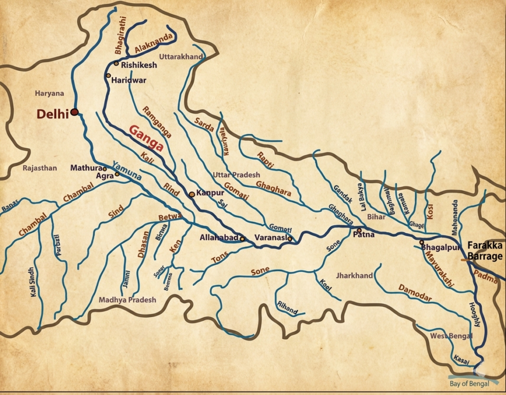
Ganga River System Map
Origin of Ganga River
- The Ganga River originates from the Gangotri Glacier in the Garhwal Himalayas, Uttarkashi district of Uttarakhand, India.
- The Ganga River’s source stream is called the Bhagirathi River, beginning at Gaumukh, the snout of the Gangotri glacier.
- Gaumukh is located at an altitude of about 3,892 meters (12,770 feet) above sea level.
- The Himalayan origin makes the Ganga a perennial river, fed by both glacial melt and monsoon rainfall.
Course of Ganga River
The Ganga originates from the Gangotri Glacier in the Garhwal Himalayas of Uttarakhand, where its initial stream is known as the Bhagirathi River. Another important tributary, the Alaknanda, merges with the Bhagirathi at Devprayag, after which the river is formally called the Ganga. Flowing southeastward across the northern plains, the Ganga traverses a distance of approximately 2,525 km before entering Bangladesh, where it is known as the Padma, and eventually empties into the Bay of Bengal through a complex delta system.
Course of Ganga River in Uttarakhand
- The Ganga originates as the Bhagirathi River from the Gangotri Glacier (Gaumukh) in the Garhwal Himalayas.
- Flows through the town of Gangotri, then moves southeast through the mountainous valleys of Harsil and Uttarkashi.
- Major right-bank tributaries join the Bhagirathi, including Jadh Ganga, Dhauli Ganga, and Bhilangna.
- Flows past Tehri, where the Tehri Dam is located, creating a large reservoir for irrigation and hydroelectric power.
- At Devprayag, the Bhagirathi meets the Alaknanda River, after which it is officially called the Ganga.
- The Ganga first emerges into the plains at Haridwar, Uttarakhand, then flows into Uttar Pradesh.
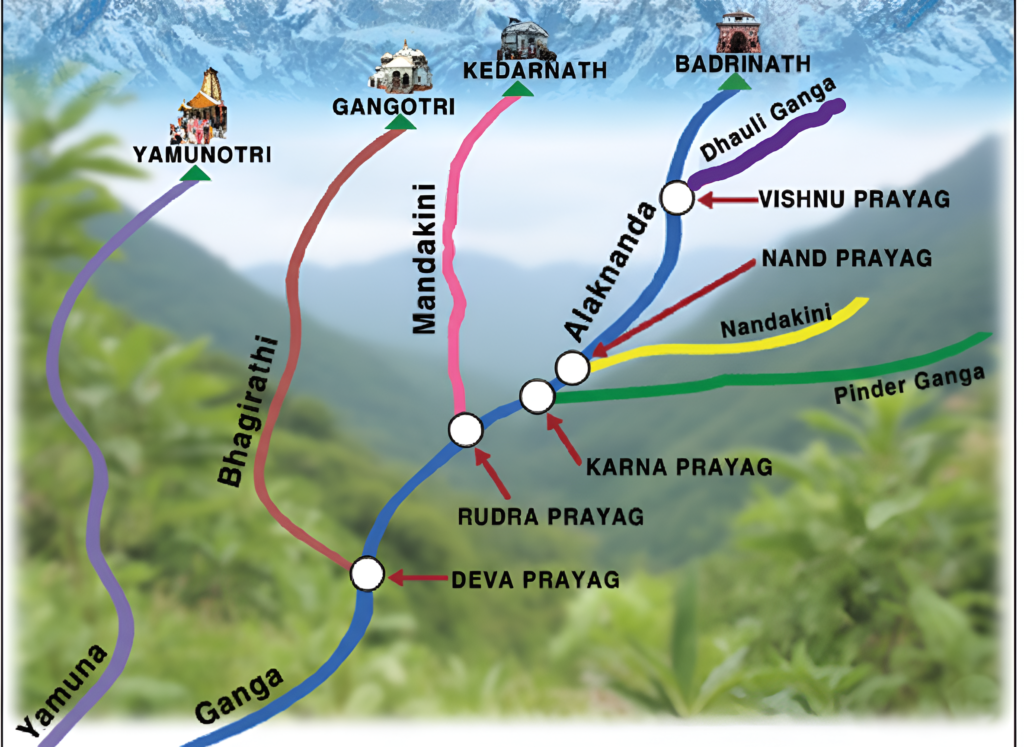
Panch Prayag
The Panch Prayag refers to the five sacred confluences of the Alaknanda River in the Garhwal Himalayas of Uttarakhand. These confluences are not only religiously significant but also mark important hydrological points along the upper course of the Ganga.
| Prayag | Confluence of Rivers | Location | Religious / Geographical Significance |
|---|---|---|---|
| Vishnuprayag | Alaknanda + Dhauliganga | Near Joshimath | Associated with Lord Vishnu; first major confluence |
| Nandaprayag | Alaknanda + Nandakini | Nandaprayag town | Linked to King Nanda; second confluence |
| Karnaprayag | Alaknanda + Pindar | Karnaprayag town | Associated with Karna (Mahabharata) |
| Rudraprayag | Alaknanda + Mandakini | Rudraprayag town | Dedicated to Lord Shiva (Rudra) |
| Devprayag | Alaknanda + Bhagirathi | Devprayag | Official origin of the Ganga River |
Course of Ganga River in Uttar Pradesh
- The Ganga enters Uttar Pradesh near Bijnor from Uttarakhand.
- It flows southeast through the upper Ganga plains, passing towns like Bijnor, Najibabad.
- Flows through Moradabad and Kannauj plains.
- The river passes through Kanpur and Allahabad (Prayagraj), where the Yamuna, a major right-bank tributary, joins the Ganga at the Triveni Sangam (Prayagraj).
- Flows eastward through Mirzapur, Varanasi, Ballia.
- Exits Uttar Pradesh near Ballia / Ghazipur, entering Bihar.
Course of Ganga River in Bihar
- The Ganga enters Bihar at the Chausa village of Buxar district, forming a boundary with Uttar Pradesh.
- The Karmanasa River joins the Ganga near Chausa (Buxar district, Bihar) just as the Ganga enters Bihar from Uttar Pradesh.
- The border segment ends where the Ghaghara River joins the Ganga near Chhapra, a significant event marking a change in the river’s course and surroundings.
- Receives major left-bank tributaries from Nepal: Gandak, Kosi, and Kamla rivers.
- Collects smaller right-bank tributaries, such as the Sone River, joining near Patna.
- It flows eastward, passing major cities like Patna, Munger and Bhagalpur before leaving the state.
- Forms a broad and fertile alluvial plain, supporting dense population and intensive agriculture, especially rice, wheat, and sugarcane.
- Experiences frequent monsoon flooding, particularly from rivers like the Kosi and Gandak.
- Flows past Bhagalpur, approaching the border with West Bengal.
- The Ganga leaves Bihar at Manihari in Katihar district of Bihar.
Course of Ganga River in West Bengal
- The Ganga enters West Bengal from Bihar near Farakka in Malda district.
- At Farakka, the Farakka Barrage diverts a portion of water into the Hooghly River for navigation and to prevent siltation at Kolkata port.
- Below the Farakka Barrage, the Ganga River splits into two main branches:
- Bhagirathi (Hooghly)
- Padma
- The Bhagirathi (Hooghly) flows right to meets the Bay of Bengal approximately 150 km downstream from Kolkata.
- The Padma flows left, entering Bangladesh and joining the Brahmaputra and Meghna before meeting the Bay of Bengal.
- Bhagirathi (Hooghly) flows southeast through the Murshidabad, Nadia, and North 24 Parganas districts, gradually widening and slowing as it enters the lower deltaic plain.
- The river ultimately empties into the Bay of Bengal through the Sundarbans delta, forming one of the largest and most fertile river deltas in the world.
Ganga-Brahmaputra Delta
- The Ganga and Brahmaputra rivers combine before entering the Bay of Bengal, forming the largest delta in the world.
- The delta lies between the Bhagirathi-Hugli, Padma, and Meghna rivers.
- Its coastline is highly irregular and deeply indented, showing a complex network of channels.
- The delta consists of numerous distributaries, small rivers, and islands, forming a dense riverine network.
- Much of the delta is covered by mangrove forests, such as the Sundarbans, which provide rich biodiversity.
- Large parts of the delta are low-lying swamps, which are flooded with seawater during high tides, making the region prone to tidal inundation.
- The delta is highly fertile, supporting intensive agriculture, especially rice cultivation, due to rich alluvial deposits.
- It plays a crucial role in navigation, fisheries, and livelihood for millions of people in West Bengal and Bangladesh.
Tributaries of Ganga River
The Ganga River System is fed by numerous tributaries, which are classified as left-bank and right-bank tributaries.
Left Bank Tributaries of Ganga River
The left bank tributaries of the Ganga mainly originate from the Himalayan region and carry a large volume of water, especially during the monsoon season. These rivers are crucial for maintaining the perennial nature of the Ganga. Important left-bank tributaries include the Ramganga, Garra, Gomti,, Ghaghara, Gandak, Burhi Gandak, Kosi, and Mahananda.
| Left Bank Tributary | Origin | Confluence with Ganga | States Covered | Key Notes |
|---|---|---|---|---|
| Ramganga | Dudhatoli Range, Pauri Garhwal district of Uttarakhand | Near Kannauj (Uttar Pradesh) | Uttarakhand, Uttar Pradesh | First major left-bank tributary in the Indo-Gangetic plains, Known as “Rathwahini” in the Skanda Purana, flows through the Jim Corbett National Park |
| Garra (Karra) | Kumaon hills, Uttarakhand | Near Kannauj | Uttar Pradesh | Small but important local tributary, flows through the Nandhaur Wildlife Sanctuary in Uttarakhand |
| Gomti | Gomat Taal (Fulhar Jheel) near Madhotanda, Pilibhit District, Uttar Pradesh | Merges with the Ganga at Kaithi, Ghazipur district. | Uttar Pradesh | Flows through Lucknow, Barabanki, Sultanpur, Jaunpur, and Ghazipur |
| Ghaghara (Sarayu) | Tibetan Plateau | Near Chhapra (Bihar) | Nepal, Uttar Pradesh, Bihar | It’s called Karnali in Nepal, Ghaghara as it enters India, and Saryu near Ayodhya, second-largest tributary of the Ganga by volume |
| Gandak | Nhubine Himal Glacier in Nepal’s Mustang District | Sonpur (Hajipur) near Patna, Bihar, India | Nepal, Bihar | Formed by the convergence of the Kali Gandaki and Trishuli rivers, also known as the Narayani and Gandaki |
| Burhi Gandak | West Champaran (Bihar) | Near Khagaria | Bihar | Old channel of Gandak, also known as the Sikrahna river |
| Kosi | Tibetan Plateau (Sapta Kosi) | Near Kursela | Nepal, Bihar | Infamous as the “Sorrow of Bihar” |
| Mahananda | Paglajhora Falls in the Darjeeling hills (Himalayas) | Joins the Ganges (Padma) River in Bangladesh near Godagari | West Bengal, Bihar | Last major left-bank tributary in India, flows through Mahananda Wildlife Sanctuary |
Right Bank Tributaries of Ganga River
The right bank tributaries of the Ganga mainly originate from the Peninsular Plateau and carry comparatively less water but a higher amount of sediment. These rivers play an important role in shaping the Gangetic plains. Major right-bank tributaries include the Yamuna, Tamsa (Tons River), Karamnasa, Son, Punpun, Kiul, Chandan, Ajay, Damodar, and Rupnarayan.
| Right Bank Tributary | Origin | Confluence Location | States Covered | Key Notes |
|---|---|---|---|---|
| Yamuna | Yamunotri glacier, Himalayas, Uttarakhand | Merges with the Ganges at Triveni Sangam, Prayagraj (Allahabad) | Uttarakhand, Haryana, Delhi, and Uttar Pradesh | Second-largest tributary of the Ganges and the longest Indian tributary, Worshipped as a goddess (daughter of Sun God Surya, sister of Death God Yama), Supplies over 70% of Delhi’s water. |
| Tamsa | Kaimur Range (Tamakund, Satna District, MP) | Joins Ganga near Sirsa (Uttar Pradesh) | Madhya Pradesh, Uttar Pradesh | Often called Tons in its lower reaches, Famous for Purwa Falls (70m drop), Mentioned in the Ramayana as the place where Rama, Sita, and Lakshmana spent their first night in exile, and where Sage Valmiki’s ashram was located. |
| Karamnasa | Kaimur Range of Bihar | Joins Ganga, Chausa, Buxar district of Bihar | Bihar, Uttar Pradesh | Forms boundary between UP & Bihar, Known for Karamnasa Falls in Bihar’s Kaimur district. |
| Son (Sone) | Near Amarkantak Hill, Chhattisgarh | Joins Ganges near Maner, Patna, Bihar | Madhya Pradesh, Uttar Pradesh, Bihar | Second-largest right-bank tributary, Features projects like the Bansagar Dam and the Indrapuri Barrage. |
| Punpun | Palamu district, Jharkhand (Chota Nagpur Plateau) | Joins Ganga at Fatuha, Bihar, about 25 km from Patna | Bihar | Traditionally believed to be the ‘Adi Ganga’, The confluence at Fatuha is linked to the Vamana avatar of Lord Vishnu. |
| Kiul | Tisri Hill Range, Giridih district (Jharkhand) | Flows into the Ganges River near Surajgarha in Munger district | Jharkhand, Bihar | Playing a vital ecological role in the region’s wetlands (Tal area). |
| Chandan | Deoghar in Jharkhand | Joins Ganga near Bhagalpur (Bihar) | Jharkhand & Bihar | Known for its historical links to the ancient Anga kingdom. |
| Ajay | Chhotanagpur plateau region, Near Batpar village, Jamui, Bihar | Joins Hooghly near Katwa in West Bengal | Bihar, Jharkhand, West Bengal | Flow through Bihar, Jharkhand (Deoghar, Jamui, Palajori, Madhupur districts), and West Bengal (Burdwan, Birbhum districts). |
| Damodar | Khamarpat Hill on Chotanagpur Plateau in Latehar district of Jharkhand | Joins Hooghly in Howrah district, West Bengal | Jharkhand, West Bengal | Known as the “Sorrow of Bengal” for past floods, but now crucial for the mineral-rich Damodar Valley’s industrial development and the Damodar Valley Corporation (DVC) projects |
| Rupnarayan | Formed near Ghatal (Paschim Medinipur district, West Bengal) by the merging of the Dwarakeswar and Shilabati rivers | Meets the Hooghly River at Geonkhali. | West Bengal | Known for its tidal nature, Home to the Kolaghat Thermal Power Station. |
Ganga River Basin
The Ganga River Basin is one of the most important and extensive river basins in India, covering parts of Uttarakhand, Uttar Pradesh, Bihar, Jharkhand, West Bengal, Madhya Pradesh, and Haryana. It plays a vital role in agriculture, economy, culture, and ecology. The basin supports hundreds of millions of people, making it the most densely populated river basin in India.
The Ganga River System flows through three major physiographic regions:
Upper Ganga Basin (Himalayan)
- This region includes the origin of the river and its early tributaries.
- Covers Uttarakhand and parts of western UP.
- Characterized by steep valleys, fast-flowing rivers, and narrow channels.
- Tributaries like Alaknanda, Mandakini, Bhilangna, Dhauli Ganga originate here.
Middle Ganga Basin (Gangetic Plains)
- Extends over Uttar Pradesh and western Bihar.
- Formed by extensive alluvial deposits, making it highly fertile.
- Receives major tributaries: Yamuna, Ghaghara, Gomti, Ghaghara.
- Supports dense population and intensive agriculture.
- Serves as the heartland of India’s grain production.
Lower Ganga Basin and Delta
- Covers eastern Bihar and West Bengal.
- This region encompasses the stretch from the confluence with the Bhagirathi-Hooghly system to the Bay of Bengal.
- Includes the Sundarbans delta, formed by distributaries such as Hooghly.
- Characterized by flat plains, rich alluvium, and high biodiversity.
State-wise Drainage Area of Ganga River
The Ganga sub-basin covers an area of about 1,086,000 sq. km across India, Tibet, Nepal, and Bangladesh, with the Indian portion accounting for 861,404 sq. km, which is nearly 26.2% of India’s total geographical area. Geographically, it is bounded by the Himalayas in the north, the Aravalis and the ridge separating it from the Indus basin in the west, the Vindhyan and Chhotanagpur plateaus in the south, and the Brahmaputra ridge in the east. In India, the sub-basin spans the states of Uttar Pradesh, Madhya Pradesh, Bihar, Rajasthan, West Bengal, Haryana, Himachal Pradesh, and the Union Territory of Delhi.
| State / UT | Drainage Area (sq. km) | Percentage of Indian Ganga Basin | Notes |
|---|---|---|---|
| Uttar Pradesh | 2,94,364 | 34.1% | Largest portion of the basin; major cities like Varanasi, Kanpur, and Prayagraj are located here; fertile Gangetic plains support intensive agriculture. |
| Madhya Pradesh | 1,98,962 | 23.1% | Includes parts of Central Highlands; Son and Chambal tributaries flow here; forests in highlands. |
| Bihar | 1,43,961 | 16.7% | Kosi, Gandak, Burhi Gandak tributaries; region prone to floods; intensive rice cultivation. |
| Rajasthan | 1,12,490 | 13.1% | Mostly western arid fringes; tributaries carry limited water; primarily irrigation-based agriculture. |
| West Bengal | 71,485 | 8.3% | Includes Ganga delta region; rivers like Bhagirathi-Hugli; dense population; Sundarbans mangroves. |
| Haryana | 34,341 | 4.0% | Tributaries from Shivalik hills; irrigation plays major role; semi-arid climate. |
| Himachal Pradesh | 4,317 | 0.5% | Upper Himalayan rivers like Bhagirathi originate here; source of Ganga and tributaries. |
| Union Territory Delhi | 1,484 | 0.2% | Small part of Yamuna basin; urbanized; important for water supply and flood management. |
| Total | 8,61,404 | 100% | Covers ~26.2% of India’s total geographical area; basin supports nearly 30% of cultivable land of India. |
Dams on Ganga River
The Ganga River, being one of the largest and most important rivers of India, has been harnessed extensively for irrigation, hydroelectric power, flood control, and water supply. Due to its long course from the Himalayan mountains to the Bay of Bengal, several dams and barrages have been constructed both on the main river and its tributaries to manage its water resources.
The upper Himalayan stretches of the Ganga, with steep gradients, are ideal for hydropower projects, while the plains are suitable for barrages and irrigation structures. These interventions not only support agriculture and energy production but also help control floods in densely populated areas.
| Dam / Project | River | Location | State | Purpose / Key Features |
|---|---|---|---|---|
| Maneri Bhali-I & II | Bhagirathi (Ganga’s headstream) | Uttarkashi | Uttarakhand | Hydroelectric projects (90 MW + 304 MW) for power generation |
| Tehri Dam | Bhagirathi | Tehri | Uttarakhand | 2400 MW hydropower, irrigation, drinking water; 5th tallest dam in the world |
| Koteshwar Dam | Bhagirathi | Koteshwar | Uttarakhand | Balancing reservoir for Tehri project; regulates water flow |
| Narora Barrage | Ganga | Bulandshahar | Uttar Pradesh | Irrigation, water regulation; supports Narora Atomic Power Station |
| Kanpur Barrage | Ganga | Kanpur | Uttar Pradesh | Water supply, irrigation control for urban and agricultural use |
| Farakka Barrage | Ganga | Murshidabad | West Bengal | Diverts water to Hooghly River for Kolkata port navigation; flood control |
Cities on the Banks of River Ganga
The River Ganga flows from the Himalayan region of Uttarakhand to the Bay of Bengal, passing through some of the most densely populated and culturally significant areas of northern India. Along its course, numerous cities have developed on its banks, serving as major centres of religion, administration, trade, industry, and agriculture. These cities reflect the geographical, historical, and socio-economic importance of the Ganga River in India’s development.
Cities on the banks of River Ganga in Uttarakhand
| City / Town | River Stretch | Location / Significance |
|---|---|---|
| Gangotri | Bhagirathi (source region) | Near the Gangotri Glacier; sacred Himalayan origin of the Ganga |
| Harsil | Bhagirathi | Small scenic town in upper Garhwal; Himalayan valley region |
| Uttarkashi | Bhagirathi | Important pilgrimage and administrative town |
| Tehri | Bhagirathi | Site of Tehri Dam; major hydropower and irrigation hub |
| Srinagar (Garhwal) | Alaknanda | Major town on Alaknanda River before meeting Bhagirathi |
| Devprayag | Bhagirathi + Alaknanda | Confluence point; from here the river is officially called the Ganga |
| Rishikesh | Ganga | Famous for yoga, pilgrimage, tourism, and spiritual centers |
| Haridwar | Ganga | Major pilgrimage city; site of the Kumbh Mela |
| Roorkee | Ganga Canal | Industrial and educational town; receives Ganga water via Upper Ganga Canal |
Cities on the banks of River Ganga in Uttar Pradesh
| City / Town | Location on Ganga | Significance / Notes |
|---|---|---|
| Bijnor | Entry point from Uttarakhand | Ganga enters Uttar Pradesh here; Upper Ganga plains region |
| Najibabad | Upper Ganga plains | Important town near the Ganga barrage system |
| Narora | Middle Ganga | Location of Narora Barrage and Narora Atomic Power Station |
| Moradabad | Middle Ganga basin | Industrial and historical town; brassware industry |
| Kanpur | Middle Ganga | Major industrial city; Kanpur Barrage regulates water |
| Fatehpur | Downstream of Kanpur | Agricultural region in the fertile Ganga plains |
| Prayagraj (Allahabad) | Confluence zone | Triveni Sangam (Ganga–Yamuna–Saraswati); major pilgrimage city |
| Mirzapur | Lower Ganga plains | Fertile agricultural belt; trading center |
| Varanasi | Middle–Lower Ganga | Ancient spiritual and cultural city; major ghats on the Ganga |
| Ghazipur | Eastern UP | Historic town on the Ganga; opium factory during British period |
| Ballia | Near UP–Bihar border | Last major Ganga city in UP before entering Bihar |
Cities on the banks of River Ganga in Bihar
| City / Town | Location on Ganga | Significance / Notes |
|---|---|---|
| Buxar | UP–Bihar border | Entry point of the Ganga into Bihar; historic town |
| Chhapra (Saran) | Near confluence with Ghaghara | Major town in northern Bihar plains |
| Patna | Middle Ganga basin | State capital; ancient Pataliputra; political and historical center |
| Hajipur | Near Gandak confluence | Important trade and transport town |
| Munger | Middle Ganga | Cultural and historical town; famous for yoga and heritage |
| Begusarai | Industrial belt | Fertilizer plant; key industrial city on the Ganga |
| Khagaria | Flood-prone plains | Agricultural town in north Bihar |
| Bhagalpur | Lower Ganga basin | Famous for silk industry and trade |
| Saharsa | North of Ganga | Represents northern Bihar plains region |
| Kahalgaon | Near Farakka | Thermal power station; last major Ganga town in Bihar |
Cities on the banks of River Ganga in West Bengal
| City / Region | River Stretch | Significance / Notes |
|---|---|---|
| Farakka | Main Ganga | Entry point of the Ganga into West Bengal; site of the Farakka Barrage |
| Jangipur | Main Ganga | Important town in Murshidabad district |
| Murshidabad | Main Ganga | Historical city; former capital of Bengal |
| Behrampore (Berhampore) | Bhagirathi–Hooghly | Administrative and commercial center |
| Nadia (Nabadwip / Krishnanagar region) | Bhagirathi–Hooghly | Cultural and religious center of Bengal |
| Serampore | Hooghly | Colonial-era town; important industrial and cultural site |
| Howrah | Hooghly | Major transport and industrial hub opposite Kolkata |
| Kolkata | Hooghly | Major port city; economic and cultural capital of West Bengal |
| North 24 Parganas | Deltaic distributaries | Part of the lower Ganga delta region |
| Sundarbans Region | Ganga–Brahmaputra delta | Mangrove forests; network of channels before the river meets the Bay of Bengal |
Facts about Ganga River
- The Ganga is the longest river in India, with a total length of about 2,525 km.
- It originates from the Gangotri Glacier at Gaumukh in Uttarakhand.
- The river is called the Bhagirathi at its source and becomes the Ganga after meeting the Alaknanda at Devprayag.
- The Ganga flows through Uttarakhand, Uttar Pradesh, Bihar, and West Bengal.
- It finally drains into the Bay of Bengal through the Sundarbans Delta.
- The river basin covers about 8.6 lakh sq km, nearly 26% of India’s total area.
- The Yamuna is the largest tributary of the Ganga.
- Other major tributaries include Ghaghara, Gandak, Kosi, Son, Gomti, and Ramganga.
- The Ganga is a perennial river, fed by both glacial melt and monsoon rainfall.
- The Ganga forms a complex network of Himalayan and Peninsular tributaries.
- The Sundarbans Delta, formed by the Ganga–Brahmaputra system, is the largest delta in the world.
- Cities like Haridwar, Prayagraj, Varanasi, Patna, and Kolkata (via Hooghly) lie on its banks.
- The Farakka Barrage in West Bengal diverts water to the Hooghly River for navigation.
- The Tehri Dam on the Bhagirathi is one of the tallest dams in India.
- The Ganga is considered sacred in Hinduism and is worshipped as Ganga Maa.
- The Kumbh Mela, one of the world’s largest religious gatherings, is held on its banks.
- The river supports agriculture, fisheries, transport, and hydropower.
- The Namami Gange Programme was launched to clean and rejuvenate the river.
- The Gangetic plains are among the most fertile regions in the world due to Ganga’s alluvial deposits.
- The river is vital for irrigation in northern India.
- The Ganga basin supports over 40% of India’s population.
- The Ganga River provides more than one-third of India’s surface water and supports over half of the nation’s total water consumption.
- The Ganga-Bhagirathi-Hooghly system from Allahabad (Prayagraj) to Haldia was declared National Waterway-1 (NW-1), a 1620 km stretch crucial for inland transport, connecting states like UP, Bihar, Jharkhand, and West Bengal, with development managed by the Inland Waterways Authority of India (IWAI).