The Brahmaputra River System is one of the largest and most powerful river systems of Asia. It plays a crucial role in the physical geography, economy, culture, and ecology of India and its neighbouring countries. Known for its massive water volume, wide braided channels, and frequent floods, the Brahmaputra shapes the landscape of the eastern Himalayan and north-eastern regions of the Indian subcontinent. The river is unique because it flows through three countries, changes its name in different regions, and follows a complex course through some of the world’s most rugged terrain.
Table of Contents
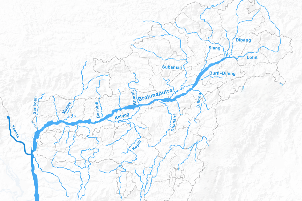
Brahmaputra River System Map
Origin of Brahmaputra River
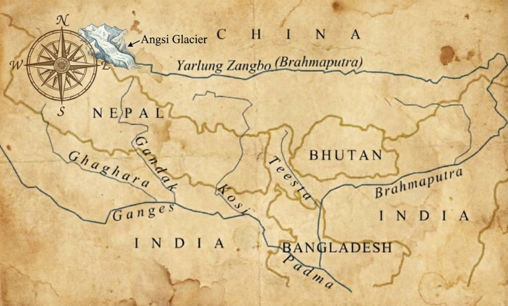
- The Brahmaputra originates in the Angsi Glacier near Mount Kailash in the Tibetan Plateau of China.
- Earlier, the Chema Yungdung Glacier was believed to be the Brahmaputra’s source, but research in 2011 confirmed the Angsi Glacier as the actual origin, though some older sources still list Chemayungdung.
- The source region lies at an altitude of about 5,300 meters (16,900 ft) above sea level.
- Its source lies in proximity to the origins of the Indus and Sutlej rivers.
Course of Brahmaputra River
The Brahmaputra River, one of the largest rivers in Asia, flows through Tibet, India, and Bangladesh, covering a distance of nearly 2,900 km. It originates from the Angsi Glacier in the Tibetan Plateau as the Yarlung Tsangpo, flows eastward across Tibet, makes a dramatic U-turn near Namcha Barwa, and enters India through Arunachal Pradesh as the Siang. In Assam, it becomes the Brahmaputra, meandering through wide floodplains before entering Bangladesh as the Jamuna, where it eventually joins the Ganga (Padma) and Meghna rivers, forming the world’s largest delta before emptying into the Bay of Bengal.
Course of Brahmaputra River in Tibet (China)
- The Brahmaputra is known as the Yarlung Tsangpo (Tsangpo) in Tibet.
- The river flows eastward along the northern side of the Himalayas in Tibet.
- It runs between the Himalayas to the south and the Trans-Himalayan ranges to the north.
- The valley through which it flows is called the Tsangpo Valley.
- The river maintains a gentle gradient in its upper course.
- It receives meltwater from Himalayan glaciers and seasonal rainfall.
- Near Namcha Barwa (7,782 m), it forms one of the deepest gorges in the world.
- At this point, the river makes a dramatic U-shaped bend around the mountain.
- After this bend, it turns southward towards India.
- It travels for nearly 1,700 km in the Tibetan region before entering India.
Course of Brahmaputra River in India
- In India, the river travels approximately 916 km, mainly through Arunachal Pradesh and Assam.
- The Brahmaputra River enters India near the village of Gelling in the Upper Siang district of Arunachal Pradesh.
- In this region, it is known as the Siang or Dihang River.
- It flows southward through the Siang Valley.
- The river is joined by two major Himalayan tributaries – the Dibang and Lohit.
- After this confluence, it is called the Brahmaputra in Assam.
- The river flows westward across the Assam Valley.
- It forms wide, braided channels with numerous sandbars (chars).
- The river causes frequent floods and erosion in Assam.
- Majuli Island, once the world’s largest river island, lies in its course.
- The Brahmaputra receives many tributaries like Subansiri, Manas, Kameng, and Dhansiri.
- Near Dhubri, the river turns southward towards Bangladesh.
Course of Brahmaputra River in Bangladesh
- The final stretch in Bangladesh spans about 375 km, where the river is called the Jamuna.
- It enters Bangladesh near Kurigram district (Bangladesh).
- The river flows southward across the Brahmaputra–Jamuna floodplain.
- It maintains a wide, braided channel with shifting sandbars.
- The Teesta joins the Jamuna (Brahmaputra) on its right bank, north of Fulchhari Ghat in the Gaibandha district of Bangladesh.
- The Jamuna (Brahmaputra) later joins the Padma (Ganga) near Goalundo Ghat in Bangladesh.
- After this confluence, the combined river flows as the Padma.
- The Padma then meets the Meghna River near Chandpur.
- Together, they form the world’s largest delta system.
- The river finally empties into the Bay of Bengal.
- The Jamuna causes frequent floods but also deposits fertile alluvium.
Tributaries of Brahmaputra River
The Brahmaputra River is fed by a large network of tributaries that originate from the Himalayas, Trans-Himalayan ranges, and the hills of Northeast India. These tributaries supply enormous volumes of water, sediments, and nutrients, making the Brahmaputra one of the most powerful and dynamic river systems in the world. They play a crucial role in shaping the river’s wide floodplains, supporting agriculture, and maintaining the rich biodiversity of the region.
Left Bank Tributaries of Brahmaputra River
The main left bank tributaries of the Brahmaputra River include the Lohit, Dibang, Subansiri, Dhanashri, Kolong, Kopili, Burhi Dihing, Desang, Dikhow, and international rivers like the Lhasa River, Nyang River, and Parlung Zangbo in its upper reaches. These tributaries contribute significantly to the river’s water volume as it flows through Tibet, Arunachal Pradesh, and Assam.
| Left Bank Tributary | Origin Area | Region / Country | Confluence with Brahmaputra | Key Notes |
|---|---|---|---|---|
| Lhasa River | Nyenchen Tanglha Range | Tibet (China) | Near Lhasa | Important tributary in upper course; glacier-fed |
| Nyang River | Eastern Himalayas | Tibet (China) | Near Nyingchi | Second largest tributary; glacier-fed; contributes water from Tibet |
| Parlung Zangbo | Eastern Himalayas | Tibet (China) | Before Namcha Barwa bend | Major Himalayan tributary in upper course; largest tributary on left side |
| Lohit River | Zayul Range | Tibet, Arunachal Pradesh, Assam | Near Sadiya | Forms Brahmaputra with Siang & Dibang; large sediment load |
| Dibang River | Mishmi Hills | Arunachal Pradesh, Assam | Near Sadiya | Joins Lohit near Sadiya before becoming Brahmaputra; largest tributary by discharge; prone to flooding |
| Dhansiri (South) | Lysang Peak, Nagaland | Nagaland, Assam | Dhansirimukh (Assam) | True left-bank Dhansiri; flows northward; forms border between Nagaland and Assam districts |
| Burhi Dihing | Patkai Hills | Assam | Dihingmukh, near Dibrugarh | Important for floodplain irrigation; oil-rich region; Namdapha River is tributary |
| Kopili River | Khasi Hills, Meghalaya plateau | Assam, Meghalaya | Kopilimukh, Nagaon district | Hydropower potential; flood-prone tributary; National Waterway-57 |
| Kolong (Kollong) | Brahmaputra distributary | Assam | Kolongpar near Guwahati | Floodplain tributary; divides Nagaon city |
| Desang | Patkai Hill Ranges, Arunachal Pradesh | Arunachal Pradesh, Assam | Sivasagar district, near Sapekhati | Known as Tisa river at source; contributes to local floods |
| Dikhow | Naga Hills | Assam | Dikhowmukh in Sibsagar | Flood-prone; joins in upper Assam plains |
Right Bank Tributaries of Brahmaputra River
The main right bank (northern) tributaries of the Brahmaputra River in India include the Subansiri, Kameng, Manas, Beki, Raidak, Jaldhaka, Teesta, Sankosh, and Siyom rivers, all flowing from the Himalayas, adding significant water and sediment to the Brahmaputra as it traverses the Assam plains before entering Bangladesh.
| Right Bank Tributary | Origin Region | State / Country Covered | Confluence with Brahmaputra | Key Features / Notes |
|---|---|---|---|---|
| Subansiri | Tibet (China) | Arunachal Pradesh, Assam | Near Lakhimpur, Assam | Largest tributary by discharge (nearly 8%), known as the “Gold River” for for gold dust deposits, Popular for kayaking, Subansiri Lower Dam located on this river |
| Kameng (Jia Bharali) | Gori Chen mountain area, Tawang district, Arunachal Pradesh | Arunachal Pradesh, Assam | Near Tezpur, Assam | known as Jia Bharali in Assam, Contributes heavy sediment load |
| Manas | Bhutan Himalayas | Bhutan, Assam | Near Jogighopa, Assam | Named after the serpent deity Manasa, A significant transboundary river, known as Drangme Chhu in Bhutan, Flows through Manas National Park, Lifeline for Manas National Park (India) and Royal Manas National Park (Bhutan) |
| Beki | Bhutan Himalayas | Bhutan, Assam | Near Barpeta, Assam | Known as the Kurissu River in Bhutan, Important flood-contributing tributary, Enters India near Manas National Park in Assam |
| Raidak | Bhutan Himalayas | Bhutan, India (West Bengal), Bangladesh | Kurigram District in Bangladesh | Known as Wang Chhu in Bhutan, A transboundary river, Known for Chukha Hydroelectric Project (Bhutan), Borders Neora Valley National Park, Gorumara National Park, and Buxa Tiger Reserve in West Bengal. |
| Jaldhaka | Bitang Lake (also known as Kupup Lake), Gangtok District, Sikkim | India (Sikkim, West Bengal) Bhutan, and Bangladesh | Enters Brahmaputra system in Bangladesh | It flows from Sikkim into Bhutan, re-enters India (West Bengal), and then enters Bangladesh, Forms part of the India-Bhutan border, Known as Dichu in Bhutan and Dharla (or Singimari) in Bangladesh, It passes through Neora Valley National Park, Chapramari Wildlife Sanctuary and Gorumara National Park in West Bengal |
| Teesta | Tso Lhamo Lake, Sikkim | India (Sikkim, West Bengal), Bangladesh | Joins Jamuna (Brahmaputra) in Bangladesh | Major transboundary river, Known for flash floods, Major projects like Teesta-V, Teesta-III, and Teesta Low Dam |
| Sankosh | Forms in Bhutan from the confluence of Mo Chhu and Pho Chhu | Bhutan, Assam | Near Dhubri, Assam | Also known as Puna Tsang Chu in Bhutan, Flows through narrow gorges in Bhutan, It serves as a natural boundary between Assam and West Bengal |
| Torsa | Chumbi Valley, Tibet (China) | Tibet, Bhutan, India (West Bengal), and Bangladesh | Meets with the Jamuna in Bangladesh | Also known as Machu (in Tibet), Amo Chhu (in Bhutan), and Teesta (in Bangladesh) |
| Siyom | Upper Siang region, Arunachal Pradesh | Arunachal Pradesh | Joins Siang (Brahmaputra) in Arunachal | The Mouling National Park is located on the east bank of the river. Known for its scenic valleys and adventure tourism (rafting/kayaking) |
Different Names of Brahmaputra River
The Brahmaputra River is known by different names along its course. In Tibet, it is called the Yarlung Tsangpo. As it enters Arunachal Pradesh, it is known as the Siang or Dihang. In Assam, it is called the Brahmaputra, and in Bangladesh, it is the Jamuna, which joins the Padma (Ganges) to form the Meghna before emptying into the Bay of Bengal.
| Region | Local Name(s) | Notes / Additional Info |
|---|---|---|
| Tibet (China) | Yarlung Tsangpo (or Tsangpo) | Name in the upper reaches; originates from the Angsi Glacier |
| Arunachal Pradesh (India) | Siang or Dihang | Name used as the river enters India; flows through the Siang Valley |
| Assam (India) | Brahmaputra | Name used throughout Assam; forms wide braided channels and floodplains |
| Bangladesh | Jamuna (western branch) | Joins the Padma (Ganges) and then becomes Meghna before flowing into the Bay of Bengal |
States Covered by the Brahmaputra River in India
The Brahmaputra River flows through several Indian states, primarily in the Northeast: Arunachal Pradesh, where it enters India as the Siang/Dihang, and Assam, where it becomes the Brahmaputra, before entering Bangladesh, also touching parts of West Bengal, Meghalaya, Nagaland, and Sikkim within its vast basin.
| State | River Name / Section | Region / Area | Key Features / Notes |
|---|---|---|---|
| Arunachal Pradesh | Siang / Dihang | Northeast India | Enters India here; flows through narrow valleys; steep gradient; hydroelectric potential |
| Assam | Brahmaputra | Brahmaputra Valley | Wide braided channels; major floodplains; river islands like Majuli; receives major tributaries |
| Nagaland | Dhansiri (South tributary) | Northeast India | Tributary from Naga Hills; joins Brahmaputra near Golaghat; flood-contributing river |
| Meghalaya | Kopili, Dhodnoi tributaries | Northeast India | Tributaries from Khasi & Meghalaya Plateau; contribute water and sediment |
| Sikkim | Teesta tributary | Northeast India | Flows into Brahmaputra in Bangladesh as Jamuna; important for hydropower |
| West Bengal | Tributary basins only | Eastern India | Some northern Himalayan tributaries (like Jaldhaka) flow through here before joining Brahmaputra in Bangladesh |
Brahmaputra River Basin
The Brahmaputra River Basin is a vast, transboundary drainage area covering Tibet (China), India, Bhutan, and Bangladesh, originating in the Himalayas and flowing about 2,900 km before joining the Ganges in Bangladesh, forming a vital, fertile, and flood-prone region known for its rich biodiversity, agriculture (especially rice), and significant hydropower potential, supporting millions with heavy monsoon-driven flows and unique braided channels in its plains.
Country-wise Drainage Area of the Brahmaputra River
| Country | Drainage Area (sq km) | Percentage of Total Basin | Notes / Water Contribution |
|---|---|---|---|
| China (Tibet) | ~2,93,000 | ~50.5% | Upper course (Yarlung Tsangpo); largest area but lower water contribution |
| India | ~1,95,000 | ~33.6% | Arunachal Pradesh, Assam, parts of Sikkim, Meghalaya, Nagaland; contributes over 80% of total water yield due to heavy monsoon |
| Bangladesh | ~47,000 | ~8.1% | Lower course as Jamuna; fertile floodplains and delta region |
| Bhutan | ~45,000 | ~7.8% | Himalayan tributaries like Manas, Raidak, Sankosh; moderate contribution to flow |
| Total | ~5,80,000 | 100% | Entire Brahmaputra basin from Tibet to Bay of Bengal |
State-wise Drainage Area of the Brahmaputra River
| State | Drainage Area (sq km) | Percentage of Indian Basin | Notes / Key Features |
|---|---|---|---|
| Arunachal Pradesh | ~81,424 | ~41.9% | Largest share of the Indian basin; river enters India here as Siang/Dihang; steep Himalayan terrain |
| Assam | ~70,634 | ~36.4% | Second largest share; Brahmaputra flows across wide floodplains; braided channels and river islands like Majuli |
| West Bengal | ~12,585 | ~6.5% | Northern Himalayan tributaries flow through here before entering Bangladesh |
| Meghalaya | ~11,667 | ~6.0% | Tributaries like Kopili and Dhodnoi originate from Khasi & Meghalaya Plateau |
| Nagaland | ~10,803 | ~5.6% | Dhansiri (South) tributary contributes to Brahmaputra flow in Assam |
| Sikkim | ~7,300 | ~3.8% | Teesta tributary flows into Brahmaputra system in Bangladesh; high hydropower potential |
| Total (India) | ~1,94,413 | 100% | Indian portion before entering Bangladesh; main water contributor due to heavy monsoon rainfall |
Dams on Brahmaputra River
The Brahmaputra River, one of Asia’s largest rivers, flows through China (Tibet), India, and Bangladesh. Due to its steep gradients in the Himalayas and heavy monsoon flows, it has significant potential for hydroelectric power generation. While the main river in Tibet (Yarlung Tsangpo) hosts several large dams and hydro projects, most of India’s dams are built on tributaries rather than the main river. These dams serve purposes such as hydropower, irrigation, and water management, and several new projects are planned or under construction in both China and India.
Dams on Brahmaputra River in China (Tibet)
| Dam / Project | River / Location | Notes |
|---|---|---|
| Zangmu Dam | Brahmaputra (Yarlung Tsangpo) | First major dam on main river; 510 MW hydroelectric capacity, Operational since 2015, located near Gyaca in Tibet, Gravity dam, Run-of-the-river |
| Jiacha Hydropower Station | Brahmaputra (mid-reaches) | 360 MW; Downstream of Zangmu |
| Dagu Dam | Brahmaputra (upper reaches) | Part of planned cascade on Yarlung Tsangpo |
| Jiexu Dam | Brahmaputra (upper reaches) | Planned dam on upper course |
| Pangduo Hydropower Station | Lhasa River | Upstream project, Lhasa River is a major tributary of the Yarlung Zangbo River (Brahmaputra) in Tibet |
| Lalho Hydroelectric Project | Xiabuqu tributary | 42 megawatts (MW), A run-of-the-river (RoR) project |
Dams on Brahmaputra River in India
| Dam / Project | River / Tributary | State | Notes |
|---|---|---|---|
| Subansiri Lower Hydroelectric Project | Subansiri | Arunachal Pradesh/Assam | India’s largest hydropower project in the basin (~2000 MW) |
| Upper Subansiri Project | Subansiri | Arunachal Pradesh | NHPC project |
| Ranganadi Dam | Ranganadi | Arunachal Pradesh | Tributary hydropower project |
| Doyang Dam | Doyang | Nagaland | Hydropower dam |
| Karbi Langpi Dam | Borpani | Assam | Hydropower project |
| Khandong Dam | Kopili | Meghalaya | Part of Kopili HE project |
| Umiam Dam | Umiam | Meghalaya | Hydroelectric + water supply |
| Nongkhyllem Dam | Umtru | Meghalaya | Hydropower dam |
| Rangit III Dam | Rangit | Sikkim | Hydropower dam |
| Rangpo Dam | Rongpo | Sikkim | Hydropower dam |
| Rongli Dam | Rongli | Sikkim | Hydropower dam |
| Jaldhaka HE Project | Jaldhaka | India/Bhutan | Shared project |
Dams on Brahmaputra River in Bhutan
| Dam / Project | River / Location | Notes |
|---|---|---|
| Chukha Hydropower Project | Wangchhu River (also known as the Raidāk River in India) | Major Bhutan hydropower station, 336MW hydro power project, run-of-the-river reservoir-based project |
| Tala Hydroelectric Project | Wangchu River | 1,020 MW hydropower station in Bhutan’s Chukha District |
| Kurichhu Hydropower Project | Kurichhu River, a tributary of the Manas River system | A run-of-the-river project, meaning it uses the natural flow of the river |
| Daguchu Hydropower Project | Dagachhu River, a tributary of the Sunkosh River | Run-of-river hydropower plant, 126 MW (2 units of 63 MW each) |
Cities on the Banks of Brahmaputra River
Several important cities and towns are situated along the banks of the Brahmaputra River, both in India and Bangladesh. In India, major urban centers include Guwahati, Dibrugarh, Tezpur, Jorhat, and Dhubri in Assam, while in Bangladesh, towns like Sirajganj, Tangail, and Chandpur lie along the lower course of the river. These cities are centers of trade, culture, agriculture, and river transport, but are also prone to seasonal flooding due to the river’s high discharge and sediment load.
| City / Town | State / Country | Location / Notes |
|---|---|---|
| Pasighat | Arunachal Pradesh, India | One of the first major towns as the river enters India; in the Siang Valley |
| Dibrugarh | Assam, India | Major tea-growing region; on the right bank of the Brahmaputra |
| Tezpur | Assam, India | Cultural and historical city; near Kameng tributary confluence |
| Guwahati | Assam, India | Largest city in Assam; major urban center on the south bank; economic hub |
| Majuli | Assam, India | River island; known for culture and Vaishnavite monasteries (satras) |
| Jorhat | Assam, India | Important city in Upper Assam; near tributaries like Desang & Dikhow |
| Goalpara | Assam, India | On the Brahmaputra floodplain; close to Dhodnoi tributary |
| Dhubri | Assam, India | Western Assam; near Sankosh tributary; historical trade center |
| Noakhali / Mymensingh / Bogura | Bangladesh | Lower course of Brahmaputra (Jamuna); fertile agricultural plains |
| Sirajganj | Bangladesh | Major river town; flood-prone area; Jamuna-Padma confluence nearby |
| Tangail | Bangladesh | Jamuna flows past this town before merging with Padma |
| Bajitpur / Chandpur | Bangladesh | Lower reaches; near Meghna delta; river splits and joins Padma |
Facts About Brahmaputra River
- The Brahmaputra is one of the largest rivers in Asia.
- Flows through three countries — Tibet (China), India, and Bangladesh — making it a trans-boundary river.
- Total length is approximately 2,900 km (Tibet: 1,700 km; India: 916 km; Bangladesh: 375 km).
- Its drainage basin covers about 580,000 sq km across China, India, and Bangladesh.
- It originates from the Angsi Glacier near Mount Kailash in Tibet at an altitude of ~5,300 meters.
- It has several regional names:
- Tibet: Yarlung Tsangpo
- Arunachal Pradesh: Siang / Dihang
- Assam: Brahmaputra
- Bangladesh: Jamuna, which joins the Padma (Ganges) to form the Meghna.
- The river flows eastward across Tibet, then makes a U-turn near Namcha Barwa, forming one of the deepest gorges in the world.
- It is joined by the Dibang and Lohit rivers in Arunachal Pradesh to become the Brahmaputra.
- Steep gradients and high discharge make it suitable for hydroelectric projects in Arunachal Pradesh.
- In Assam, the river forms wide braided channels, river islands, and sandbars (chars).
- Major left-bank tributaries include Lohit, Dibang, Kameng, Dhansiri (South), Burhi Dihing, Kopili, Kolong, Desang, Dikhow, Dhodnoi, Sankosh, Lhasa, Nyang, Parlung Zangbo.
- Major right-bank tributaries include Subansiri, Manas, Beki, Raidak, Jaldhaka, Teesta, Siyom, Sankosh (Torsa), Kameng (northern flow).
- The river is flood-prone, particularly during the monsoon season (June–September).
- Seasonal floods deposit fertile alluvium, supporting agriculture in Assam and Bangladesh.
- It flows into Bangladesh as the Jamuna, which later joins the Padma (Ganges) and becomes the Meghna before emptying into the Bay of Bengal.
- It contributes to one of the world’s largest delta systems with the Ganga and Meghna.
- Major cities on its banks include Pasighat, Dibrugarh, Tezpur, Guwahati, Majuli, Jorhat, Goalpara, Dhubri in India, and Sirajganj, Tangail, Chandpur in Bangladesh.
- It supports rice, jute, tea, and other crops, and provides inland water transport.
- Hydropower potential is high in Arunachal Pradesh due to steep gradients and heavy discharge.
- The river flow through the Kaziranga National Park, which is famous for one-horned rhinoceros, elephants, tigers, and migratory birds.
- Many tributaries carry glacial meltwater and sediments from the Himalayas, Patkai, and Meghalaya hills.
- Majuli, a river island in Assam, is one of the largest river islands in the world.
- The Brahmaputra forms dynamic channels that frequently change course due to sediment deposition and floods.